


Chapter 1: India - Location
.jpeg)
Q1. Write latitudinal and longitudinal extension of India.
Q2. What is IST? Why it is important?
Q3. Why exactly 82°30' N is considered as the standard meridian in India?
Q4. Discuss about the location and size of India.
Q5. What are the differences between gulf and strait?
Q6. What are the advantages of India having long coastline?
Q7. Do you think that India is needed more than one standard time? - explain your valuable suggestion.
Q. 1 Explain the brief description of India.
Answer Key Points: -
1) Location: - India is a vast country lying in the Northern Hemisphere, the mainland extends between latitude 8° 4’ and 37° 6’ North and longitudes 68° 7’ and 97° 25’ East.
2) Line of Latitude: - The Tropic of Cancer (23° 30’ North Latitude) divides the country into almost two equal parts.
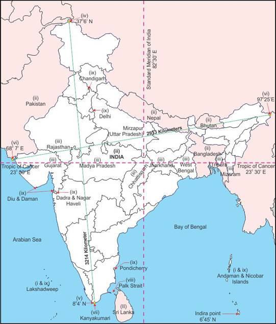
3) Island Groups: - The Andaman and Nicobar Islands lies in the Bay of Bengal and Lakshadweep Islands in the Arabian Sea.
4) Size: - The landmass of India has an area of 3.28 million sq. km which accounts for or 2.4% total geographical area of the world.
5) Land Bounder: - India has a land boundary of about 15,200 km and the total length of the coastline of the mainland including Andaman Nicobar and Lakshadweep islands is 7,516.6 km.
6) Mountains: - India’s Northern border is covered by World’s Highest Mountain series called Himalayan Mountain.
Q. 2 What is the Standard Meridian of India? Why it has been so selected?
Answer Key Points: -
The Earth has been divided into 24 time zones of one hour each. Each of these zones covers 15 degrees of longitude (15X24=360). We have selected 82° 30’ East longitude as Standard Meridian of India.
.jpeg)
1) It was accepted as it lies almost in the middle of the country.
2) It has prevented a lot of confusion and has brought harmony in time throughout the country.
3) It has accepted to follow one-timing because the local time at each longitude is different by 4 minutes which would create a lot of confusion regarding time for any country which may stretch across several longitudes.
Q. 3 Does India need to have more than one standard time? If yes, why do you think so?
Answer Key Points: -
1) Yes, India needs to have more than one standard time, because there is a time gap of about 2 hours between the easternmost parts to westernmost parts to westernmost parts of the country.
.jpeg)
2) The longitudinal extent of India is large i.e. 30° approximately. So even when the sun is still shining in the western coast, it is already night in the northeast. So, we need two or three time zones
to clearly reflect diurnal changes.
3) There are some countries where there is more than one standard meridian due to their vast east-to-west extent. For example, the USA has 11 time zones.
Q. 4 What is the central location of India?
Answer Key Points: -
1) The Indian landmass has a central location between the East and the West Asia.
2) The trans-Indian Ocean routes which connect the countries of Europe in the West and the countries of East Asia provide a strategic central location to India.
3) The Deccan Peninsula extends into the Indian Ocean, helping India to establish close contact with West Asia, Africa and Europe from the western coast and with Southeast and
East Asia from the eastern coast.
4) No other country has a long coastline on the Indian Ocean as India. India's important position in the Indian Ocean justifies the naming of an Ocean.
Q. 5 Give the main features of coastline of India.
Answer Key Points: -
1) India has a total length of the coastline of 7516.6 km, out of which mainland coastline is of 6100 km.
2) Indian coastline touches nine states and four union territories. The nine states are Gujarat (1214.7km), Maharashtra, Goa (160.7 km), Karnataka, Kerala, Tamil Nadu, Andhra Pradesh, Odisha and West Bengal.
.jpeg)
3) Union Territories include Daman & Diu, Puducherry, Andaman & Nicobar Islands and Islands.
4) Gujarat has the longest (1214.7 km.) and West Bengal has the smallest (157.5 km.) sea coastline in India.
5) India’s mainland coastline is divided into: -
a) ‘The Eastern Coastline’ includes Eastern Ghats and the Bay of Bengal that extends from Ganga Delta in the North to Kanyakumari (Tamil Nadu) in the South.
b) ‘The Western Coastline’ extends from Rann of Kachchh (Gujarat) in the North to Kanyakumari in the South.
6) Eastern coastline is further divided into Utkal Coast also called Northern Circars (West Bengal to Andhra Pradesh) and Coromandel Coast (Andhra Pradesh to Tamil Nadu).
7) Western coastline is divided into three parts, Konkan Coast (Maharashtra to Goa), Kannad Coast (Goa to Karnataka) and Malabar Coast (Karnataka to Kerala).
8) The sands of Kerala coast have large quantity of Monazite, which is used for nuclear power. Low lying areas of Gujarat are famous for producing salt.
9) India’s long coastline has 13 major and 185 minor ports which have great economic importance.
10) Fishing is an important occupation of the people living in the coastal areas of India.
Q. 6 Why is India said to enjoy a strategic position with reference to the international trade? Or
How is India's geographical location favourable for international trade?
Answer Key Points: -
1) Due to its Central location at the head of Indian Ocean the countries of East Africa West Asia, South & Southeast Asia and East Asia could be reached through sea routes.
2) Unlike landlocked countries it has an easy access to outside world.
.jpeg)
3) India is connected with Europe North America and South America through both the routes of the Cape of Good Hope and the Suez Canal.
4) India can also reach Canada and USA through the Strait of Malacca after crossing the Pacific Ocean.
5) India is favourably located on the world's Highway of trade and commerce both the east and the west.
6) It has helped in establishing close cultural and commercial contact with these countries.
Q. 7 Why Ahmedabad and Kolkata are able to see the noon Sun exactly overhead in a year but not Delhi? Explain.
Answer Key Points: -
1) Ahmedabad has latitude 23 degrees North and Kolkata 22.5° (degrees) north; Delhi is at latitude 28° (degrees) north.
2) This means that the first two cities lie within the Tropic of Cancer and it is the latitude that marks the apparent position of the Sun at the time of the Northern Solstice.
3) It is also the farthest North latitude at which the sun can be directly overhead so in Delhi the sun is never directly overhead.
.jpeg)
.jpeg)
Share your knowledge with others